


6 la bastide puylaurent-les alpiers

joelinou
User
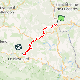

Length
27 km

Max alt
1417 m

Uphill gradient
902 m
Km-Effort
39 km

Min alt
1018 m

Downhill gradient
746 m
Boucle
No
Creation date :
2019-08-08 18:06:25.614
Updated on :
2019-08-08 18:07:19.265
--
Difficulty : Difficult

FREE GPS app for hiking
 SityTrail
IGN / Geographical institutes
SityTrail Plus
The world is yours!
About
Trail On foot of 27 km to be discovered at Occitania, Lozère, La Bastide-Puylaurent. This trail is proposed by joelinou.
Description
GR70 STEVENSON
Positioning
Country:
France
Region :
Occitania
Department/Province :
Lozère
Municipality :
La Bastide-Puylaurent
Location:
Unknown
Start:(Dec)
Start:(UTM)
571853 ; 4938009 (31T) N.
Comments